
SOOSmap – a Data System for the Southern Ocean

SOOS represents an international network of stakeholders and contributors that have common interest in enhancing sustained, integrated and multidisciplinary observations of the Southern Ocean. Data integration and standardisation underlines all aspects of SOOS data delivery. Therefore, the Southern Ocean Observing System (SOOS) in collaboration with the EMODnet Physics and Southern Ocean Carbon and Heat Impact on Climate (SO-CHIC) developed SOOSmap – a portal that provides access to a broad spectrum of data products across multitude of data providers and science disciplines. Specifically, it is an interactive web interface for oceanographic data visualisation and dissemination, that allows users to discover and access circumpolar data coming from several international research centres and data assemblers, oceanographic repositories and marine infrastructures in the Antarctic.
The development and hosting of SOOSmap are provided by EMODnet Physics within the scope of supporting regional ocean observing systems under EMODnet for Global in order to integrate and make accessible and interoperable real-time data on the physical condition of European and international seas, using the latest IoT, Big Data, webGIS technologies and open protocols.
SOOSmap is also supported by SO-CHIC, aimed to improve understanding of the exchanges of heat and carbon between the atmosphere and the deep ocean, to quantify their flows in the air-sea-ice interface, estimating the interannual variability of the build-up of heat and carbon in the Antarctic Ocean, contributing to the study of global climate change.
The SOOSmap portal exists for several years but has undergone a significant redesign in the last 18 months.
The current SOOSmap, Version 2, has been developed in Javascript-Angular environment and populated using the existing data infrastructure composed by Geoserver / Erddap/ ncWMS.
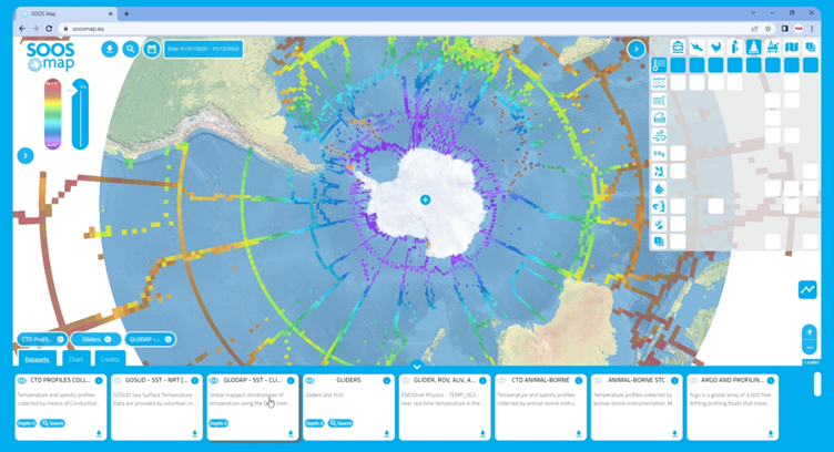
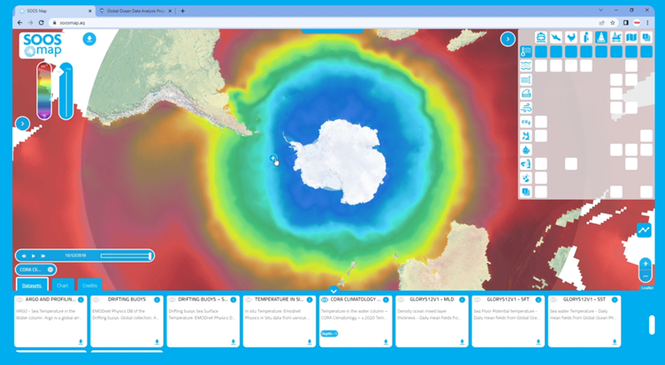
The portal includes more than 50 data layers, offers a faster and smarter experience, a deeper and more accurate data exploration and a more interactive analysis.
In particular, the current SOOSmap offers:
- improved responsiveness and loading speed of any data layers
- design and creation of graphic call-to-action buttons and icons to obtain zoom and insight about specific data layer with information links and a platform page link
- development and implementation of DATASET FILTER MATRIX to enhance the user journey and to explore specific and custom combinations of platforms
- integration of SOOS-specific data layers (i.g.: penguin colony, krill, mooring buoys, gene sequences, and plastics pollution data)
- design and implementation of DATASET CARDS PANEL to offer an easy-to-use and intuitive visualisation and to support the download of large and complex composite datasets
- Google Analytics integration has also been implemented to accurately track usage of SOOSmap Version 2
Users can select a map base layer and visualise datasets from a data filter matrix with platforms (columns) and data types (rows). Platforms include for example ship, glider, drifting buoys or marine mammals. Data types and parameters include for example temperature, salinity, sea level, biogeochemistry or biology. Users can also explore gridded data products or view data profiles and download data of the available parameters in the data format they prefer to work with.
More details on the SOOSmap functionalities can be found in the SOOSmap tutorial.
Aggregating a multitude of data on a single map can help to highlight gaps in observations and data sharing efforts, to identify new collaborations or serve as an educational tool.
Release of the SOOSmap is not the end but the beginning! We now present this discovery tool of Southern Ocean observational efforts to the SOOS community to elicit discussion, encourage contributions for new data layers and to seek guidance of the community needs.
We invite you to explore the SOOSmap and get in touch with comments and suggestions to data@soos.aq or for technical support to helpdesk@emodnet-physics.eu.